Why visit ACE ’25?

ForeFlight is introducing new subscription regions to facilitate the future rollout of government charts, documents and localised data for countries in these regions.
ForeFlight Mobile is already well-suited for pilots anywhere in the world, thanks to its extensive global datasets for terrain, obstacles, aeronautical data and more, in addition to its integration with Jeppesen charts, enabling global flight planning and inflight use. Government-sourced charts and documents for a smaller set of countries and regions, namely the US, Canada, Australia and Europe, have previously been available as included or paid add-ons to each subscription plan.
With the release of ForeFlight version 15.11, pilots who fly outside these regions can now purchase or update their subscriptions to reflect the region they fly in. The newly-added regions include Latin America, Africa, the Middle East and south Asia, Asia and Pacific, and New Zealand. ForeFlight customers with these regions will gain access to government charts, data and documents as this data is sourced, processed and released by the ForeFlight team over time.
"Pilots around the world are already using ForeFlight, whether that's to plan flights using our extensive global aeronautical database or use powerful features that enhance safety and situational awareness," says director of product for international Josh Tahmasebi. "Adding these new regions is the first step in being able to deliver new charts, data and documents to more pilots around the world. We encourage pilots to ensure their subscription includes the regions that best suit their needs as this will ensure they quickly receive data updates as they become available."
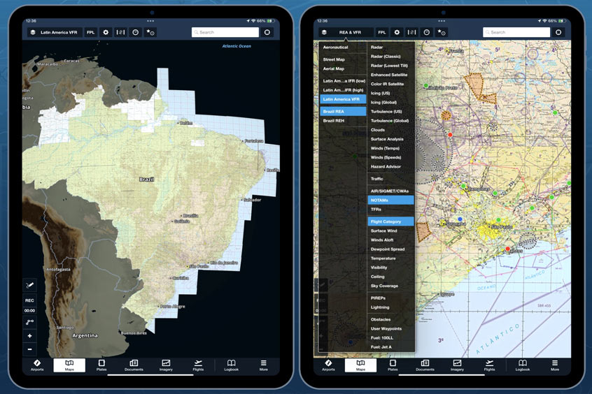
Pilots in Brazil can already benefit from this change with the introduction of government charts, data and documents from Brazil's Department of Airspace Control (DECEA) as part of the new Latin America region.
As additional charts, data and documents become available, ForeFlight has introduced a new tool to easily see what is available in each country.
ForeFlight subscriptions include one region by default, but customers can purchase additional regions for an added cost to better support flight planning and flying across multiple regions. While customers may also purchase one or more Jeppesen chart coverages as part of their ForeFlight subscription, note that these coverages do not relate to or depend on a customer's selected subscription region, which only confers government charts and local data for that region, if available.
"We have witnessed tremendous enthusiasm and success in the regions we currently support, which has been a driving force behind our continued expansion," says CEO Tim Schuetze. "With these new region offerings, we are poised to accelerate the delivery of software and data products to existing and new customers, enabling us to provide the most comprehensive flight resources to pilots around the world."
The company has also released an Oceanic Plotting solution, which streamlines the process of recording position reports, conducting GNE checks and maintaining a master flight log with an integrated workflow for pilots. It builds on top of its existing Active Navlog product, released in May 2023, and integrates seamlessly with ForeFlight Dispatch's existing contingency planning capabilities. The combination of Active Navlog and Dispatch enables fully paperless oceanic plotting directly in ForeFlight Mobile, allowing operators to eliminate the use of paper charts for both plotting and record-keeping. As with the base Active Navlog product, performance estimates are automatically re-calculated during the flight as pilots record time and fuel actuals at each waypoint.
Pilots can easily record position reports and Gross Navigational Error (GNE) checks. Every GNE check is automatically recorded in the master flight log with an associated screenshot, while completed navlogs are automatically uploaded to ForeFlight Dispatch and attached to the flight plan for easy retrieval.
"Logging position reports and GNE checks have been a manual, time-consuming task for our customers and we're excited to introduce our integrated digital solution to simplify and streamline this process," says Kevin Sutterfield, ForeFlight and Jeppesen global sales leader. "We actively incorporated customer feedback through the development of this feature to ensure we directly addressed the specific challenges and needs expressed by pilots and operators. The Oceanic Plotting feature simplifies the process of oceanic crossings for pilots while also automating the regulatory compliance required for those operations."
Oceanic Plotting is available now as part of Active Navlog, which is a per-user add-on product for ForeFlight Business subscriptions. ForeFlight Dispatch is also required to enable Oceanic Plotting, while Active Navlog is available with or without a Dispatch subscription.